Home › Forums › Horse Racing › Topology of UK Racecourses
- This topic has 14 replies, 7 voices, and was last updated 7 years ago by
bobble.
-
AuthorPosts
-
August 8, 2017 at 17:42 #1313279
Can anyone direct me to a website illustrating the topology of those UK Racecourses that are not flat? When trying to assess form, its one thing to consider that a track may be described as undulating but without having a visual representation of the rises and falls in elevation and where these occur, its sometimes difficult to explain performances especially for those interested in sectional timings. The nearest I’ve seen was ITV’s coverage of the Epsom Derby meeting where they used a topology model to show the undulations of this track and how and where the elevation changes for different race distances.
August 8, 2017 at 20:07 #1313284I believe Simon Rowlands, who sometimes posts here (as Prufrock) uses Google Earth. If so, it’s safe to assume no better tool is available.
August 8, 2017 at 23:51 #1313302Newbury is thought of as a “flat course”, but didn’t seem very flat when I ran around it once. Surprised me that both the back straight and home straight are both gradually uphill. Starts to descend (more rapidly than you’d notice by the cameras) from the end of the back straight, levels out around the home turn before another short only very slight downhill at the start of the straight, then gradually climbing to the finishing line.
Value Is EverythingAugust 9, 2017 at 08:24 #1313318When I first started compiling speed figures, to bring all the different racecourse configurations and race distances into line, I came up with my lbs per length formula.
Example:
Epsom 5f = 3.63 (run downhill, the higher the figure the easier the trip)
Pontefract = 3.25 (last 2 furlongs run uphill)The difference between the two race distances is 0.38 (1.9 lengths)
You will find all lbs per length figures in my standard time list.
Standard times: https://drive.google.com/open?id=0B3rVp0WNvwn8anUySlNvSjN1bXMMike.
August 9, 2017 at 10:24 #1313320The Racing Post maps are reasonable: they point out the highest and lowest points, make an attempt to illustrate the topography and have the Google satellite image attached, though Streetview doesn’t seem to be working: the little chap is taking a walk at midnight on my browser
Type course name in to the search box, click course on the drop down menu, click name of course and on the course pop-up click ‘course map’
That’s how I did it anyway!
August 9, 2017 at 15:23 #1313353Cant get the photo to display on the forum.
Here’s a link to the Towcester 2 mile course. You can do this with Google Earth using the elevation profile tool.
August 9, 2017 at 19:55 #1313376That’s a great tool Cav, thanks; and despite having had Google Earth for years have never tried it
What more could the OP wish for?
Had a go with York’s 14f course and it fluctuates by about 3m around the mean, comapared to about 15m at Towcester. No surprise there!
August 9, 2017 at 20:37 #1313377Cav, do I need to download Earth? Can’t seem to even drop a pin never mind plan a route on the online version.
August 9, 2017 at 21:14 #1313380Hi Joe
You’ll need to get the download version of Earth alright.
Then click on the ruler icon near the top center.
Then click on Path.
When that window opens tick the “Show Elevation Profile” at the bottom left. August 10, 2017 at 10:46 #1313410
Thanks, Cav. I see Google Earth Pro is now free. Might as well download that one.
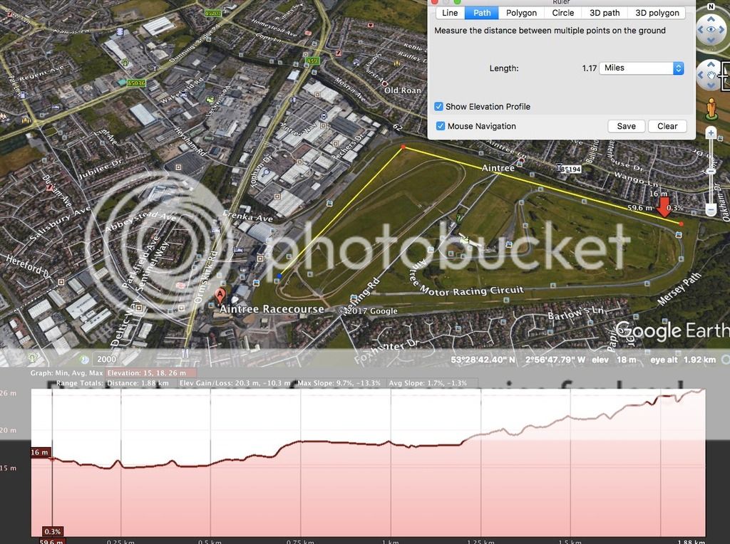
August 10, 2017 at 22:55 #1313466Aintree, described by Timeform as “perfectly flat throughout” rises 10 metres from Canal Turn to winning post according to Google Earth
 August 11, 2017 at 11:06 #1313489
A 10m rise over a run of 1880m (1.17miles) is a gradient of 1:188 or as a percentage 0.53%. So, largely negigible and it is of course countered by the commensurate drop of 10m from start to Canal Turn
These graphs are very good but the axes are not set to the same scale: the path (x-axis) is squeezed to fit the page, hence the undulations, inclines and declines are significantly amplified which gives a false sense of their maginitude
That said, what strikes me about Aintree is how free of undulations it appears to be: the gradual incline is more or less linear, which is perhaps what Timeform mean by ‘perfectly flat’
August 11, 2017 at 16:01 #1313510Fair points, Drone. I’m rubbish at physics but wouldn’t the same energy need to be expended to climb that final 10M whether it was over a mile or a 100 metres? Intensity obviously different but overall???
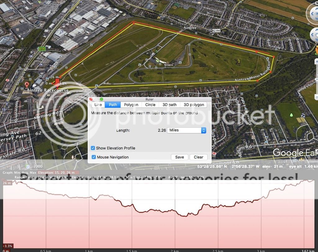
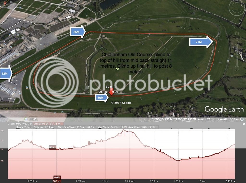
I just did Cheltenham Old Course and the climb from the turn-in to the post is just 8M according to GE. A good trivia question if nothing else: “which rises more, the GN course from the Canal Turn or the final hill at Cheltenham?”
 August 11, 2017 at 16:10 #1313511
BTW, here’s that Cheltenham profile.
 October 20, 2017 at 02:38 #1322380
I would just like to thank everyone for the useful insights and especially Thebluesbrother for sharing his Standard Times which I suspect will prove very helpful up the road
-
AuthorPosts


- You must be logged in to reply to this topic.